

Diagram (left) and images (right) of the tidal cabin before and after incorporation into the new headquarters of the Adriaco Yacht Club in 2004
The tide station of Trieste is the oldest in the Adriatic and the first tidegraphic observations date back to 1859 by the Imperial Royal Academy of Commerce and Nautical.
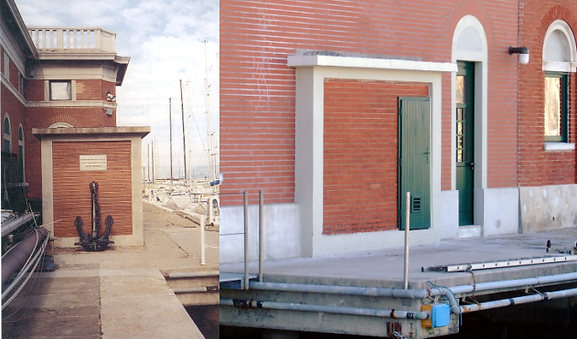
The station is managed by the Trieste Operational Unit of the CNR Institute of Marine Sciences (ISMAR) and is located in a cabin on the NE side of the Sartorio Pier. The tidal cabin in 2004 was incorporated into the renovated structure of the Adriaco Yacht Club headquarters.
The geographical coordinates are: latitude 45 ° 38 '50.0 "North, longitude 13 ° 45' 33.9" East.
In the Mediterranean, with the exception of the Black Sea, there are only four tidal stations with at least 80 years of observations in addition to that of Trieste, namely Genoa (from 1884), Marseille (1885), Venice (1872) and Marina di Ravenna (1896). The last two sites are notoriously affected by marked subsidence of mainly anthropogenic origin.
The station is currently equipped with three OTT float tide gauges . Specifically, two digital tide gauge Thalimedes model and one analogue are installed. One of the two Thalimedes is currently connected to the hydrometeorological network of the Friuli Venezia Giulia Regional Civil Protection and transmits the sea level data collected every 30 minutes.
The second Thalimedes is included in the ISMAR Trieste meteomarine network and records the exact sea level heights measured every minute.
The analogue recordings on paper are instead collected on a weekly basis during the periodic calibrations carried out by means of an electric contact hydrometer with metric tape. In this way, the level heights are measured with respect to the tide gauge plate for a simultaneous comparison of the latter with those recorded by the instruments. The redundancy of the sensors guarantees the continuity of the recordings even in the event of mechanical and / or electrical malfunctions.
The main function of the tide gauge cabin, in addition to housing the instrumentation, is to host a cockpit that opens onto the floor and is connected to the open sea through a hole, whose section is equal to 1/400 of the horizontal section of the cockpit. With this expedient, sufficient attenuation of the high frequency oscillations caused by the wave motion is obtained, but those with a longer period of tidal relevance are preserved.
A-AMS's collaborations

The sea level is a height which, at a given moment, separates the sea surface from a conventionally identified and usually quoted reference plane with respect to the national altimetric network.
In Trieste, this plan corresponds to the "Zero Thalassographic Institute (ZIT)" located 2,333 m below the IGM horizontal benchmark 39, 2,778 m below the Molo Sartorio floor

The "full"
Exceptional high water in Trieste in a photo from the late 19th century