By Marco Virgilio
Meteorological Trend Week n. 48 - 29 November - 5 December 2021
The first meteorological winter type weather event is almost over, the structure of the pressure fields at high altitudes, scheduled for next week, should favor a prevalence of northern flows at high altitudes with drier and more stable air than now, with one possible exception being the day 2 December for the Alpeadria macro-region.
THE SYNOPTIC
So, let's try to understand the possible synoptic evolution between Monday 29 November and Sunday 5 December, the week in which winter begins for the conventions of Meteorology. We will use the main global numerical models ECMWF and GFS. The two main models are in agreement until Friday 3 then diverge over the weekend.
After the eastward transit of the depression, responsible for the current weather, a new meridian pulsation of the Atlantic anticyclone could occur with a corresponding transfer of cold masses towards the western Mediterranean.
The formation of the new depression and the attached cold front seem destined to shift rapidly between Thursday 2 and Friday 3, reserving limited effects to Friuli Venezia Giulia and Slovenia.
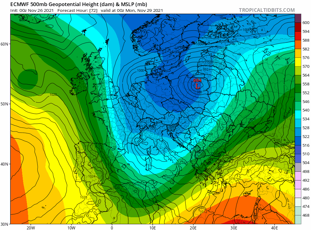
Synoptic evolution at the isobaric altitude of 500 hPa elaborated by the ECMWF model: apart from a possible and rapid frontal transit on day 2 during the new week, northern currents will prevail.
It’s interesting to note how the Jet Stream on Thursday 2 transits on the Italian northwest with northerly winds above 220 km/h on the northwest, partially flaking off and reaching the Alpeadria with speeds below 180 km/h and destined for a very rapid attenuation. At the same time, between Cyrenaica and the eastern Mediterranean, the Jet Stream will intensify up to over 230 km/h.
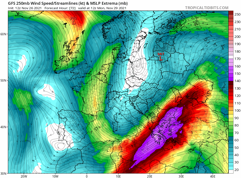
Animation related to the dynamics of the jet stream after the new Atlantic anticyclonic pulsation expected in the middle of the new week
After this episode, the analysis of the global models, of the Ensemble scenarios and expected trend of the NAO (North Atlantic Oscillation) index, indicate a probable anticyclonic expansion between central-western Europe and the western Mediterranean with a new rotation of winds at altitude and establishment of a flow of northern currents, humid on the north alpine side, drier on the south side. This, if confirmed, would mean a stable and dry end of the week for the Alpeadria area with skies between partly cloudy and partly cloudy.
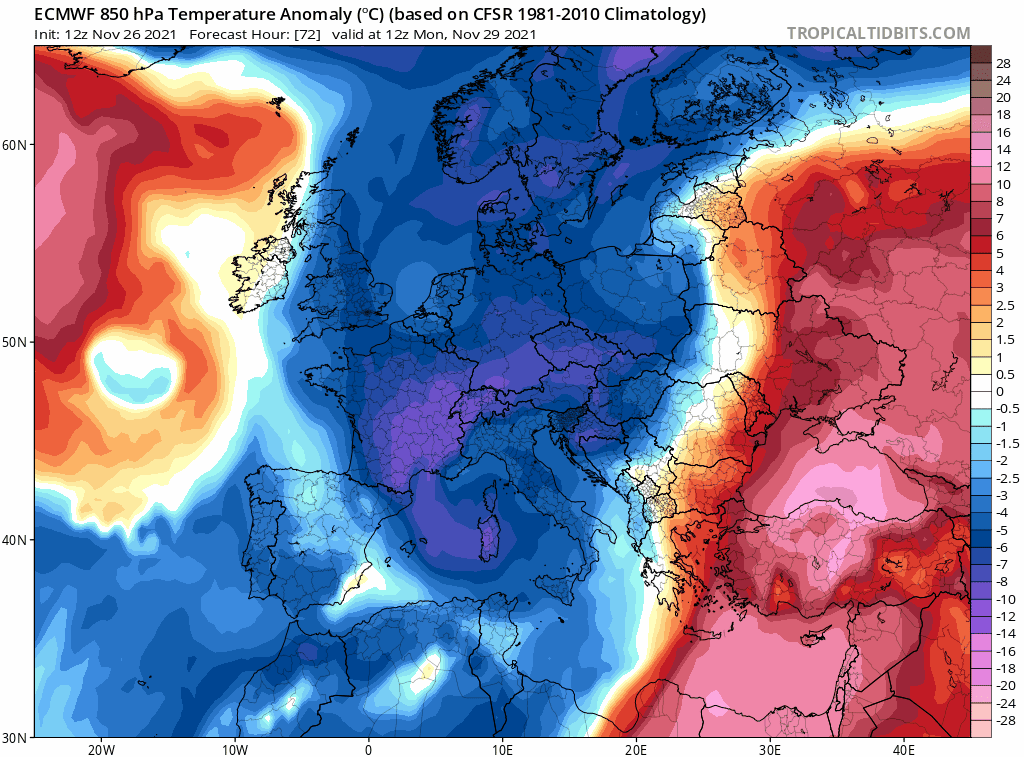
It should be remembered that the reliability of the projections tends to drop significantly after 5/6 days. Also in this case the Ensemble scenarios, quite in agreement up to day 1, tend to diverge considerably between the 3rd and the 5th. This consideration, applied to the type of presumable synoptic framework, can refer above all to the thermal field.

ENS-ECMWF scenarios (temperature at 850 hPa) are related to the city of Trieste but significant for the area of interest.
PRECIPITATION
With the current synoptic evolution forecast, we can expect the total cessation of rains and snowfalls at low altitudes in the Alpeadria sector by Sunday night. The entry of northern winds at high altitudes should inhibit rainfall until Wednesday 1 December. We will have to verify the impact of the possible and brief event, which can be localized between Thursday 2nd and the following night, which at the moment does not seem capable of generating rainfall of more than 10 mm between Friuli Venezia Giulia and Slovenia.
A prolongation of rain and snowfall, with low intensity, up to the lowest altitudes between Tyrol and Salzburg, can be expected due to the Stau effect. On the other hand, between Friday 3 and Sunday 5, the revival of the northern flows will favor the return of dry weather with variable cloud cover in Friuli Venezia Giulia and Slovenia.

The precipitation forecast for week 48-2021. In green and yellow is the rain, in blue is the snow (model GFS).
TEMPERATURE
According to global models and Ensemble scenarios, the whole of next week will be characterized by the presence of air masses with a negative anomaly between 1 and 3 degrees at the 850 hPa isobaric surface. After a first more significant decline between 28 and 30 November, the isotherms will suffer fluctuations due to the transit of the front on Thursday 2 but, in general, will not be able to rise to the average values for the period. After the frontal transit, they will always remain around 2 degrees below the norm.
With these premises and with the possibility of having some clear nights, the minimum temperatures will drop below zero even in the lowland areas with values up to -2 / -5 degrees in Friuli Venezia Giulia, peaks up to -6 / -10 degrees in Slovenia. and intense frosts in the alpine valleys.
A modest increase in temperatures is looming on Thursday with the passage of the front and in the following days.
The temperature anomaly forecast at the isobaric surface of 850 hPa for week 48-2021 (ECMWF model).
SNOW
Between Monday and Wednesday, no snowfalls are expected except on the northern alpine side between Voralgberg, Tyrol, and Salzburg. The transit of the front, if confirmed in its dynamics currently seen by the models, could cause snow accumulations of no more than 5/10 cm on the reliefs of Friuli Venezia Giulia and Slovenia around 500 meters above sea level.
Several more cm will fall on the north alpine side where the rainfall will last longer.

Thursday 2 December could be the only day with rainfall next week (48-2021).
What has just been described represents a synoptic trend based on modeling products freely available on the net, and does not constitute a weather forecast.
For day-by-day weather forecasts for the Alpeadria region, we suggest to look at the weather bulletins provided by the official meteorological services Osmer-Arpa, Zamg, Arso
The maps reported and discussed in this article are taken from the tropicaltidbits.com portal. For model updatings we suggest referring directly to the web portal.